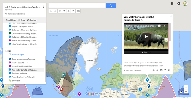
 Last year I used Google Maps for an end product for our research on Endangered Species. This was a part to a bigger on human impact to species adaptations and evolution. I broke the class into the four hemispheres and each hemisphere had to create a map. Each Member Created a "pin" with the information on the animal or plant they chose in that hemisphere. Here is the link to what was required Map Requirements and a screen shot of one of my classes
Making the maps and creating the pins was a quick learning curve. The tough part was having them share the Map with me to make a class map. That took many tries and clicks on the help button. That turned out to be a good learning experience in itself. Students really liked learning the Tech skill of google maps. Some even plotted out their spring break vacation. I hope to use it for mapping earthquakes and volcanoes this year so kids can discover the Plate Boundaries. Kids can upload real time data from the USGS website right to their map. We could use the boundaries feature to plot the seismic waves and lava flows. Research individual events and post photos, information and videos. You can also change the terrain features to get a map version or earth topography. Maybe use the map and direction features for evacuation routes. Who knows what else the kids will think of. I think this could be the right tool for many things. I got the idea of using it from a Social Studies teacher that used it for his students portfolio. They plotted as they learned about us history throughout the year.I could see using it math to plan and budget a road trip. English plot settings maybe. Ideas are endless.
1 Comment
Scott Marsden
2/27/2018 05:39:01 pm
Thank you for sharing this great tool, Jeff. I've always wanted to use Google Maps (or Google Earth) but never gotten around to it. Seems like it would be great for science or social studies. Leave a Reply. |
AuthorJeff Albertazzi Archives
November 2018
Categories |
 RSS Feed
